


Determined prospectors find ways to explore in a more environmentally-acceptable and cost-effective manner
By Steve Fiscor, Editor-in-Chief
Exploration professionals packed the room when Dawson City Prospector Shawn Ryan delivered his presentation at the recent Prospectors and Developers Association of Canada (PDAC) meeting in Toronto. Speaking in a session titled Closing the Discovery Gap: The Role of Innovation, Ryan discussed how he and the crew at GroundTruth Exploration continue to pursue their passion even when funding is tight.
Ryan won the Bill Dennis Prospector of the Year Award in 2011, which recognized his achievements for gold discoveries in the Yukon. Prospecting in Klondike gold fields for more than 20 years now, he identified the anomaly that led to the White Gold deposit, which was acquired by Kinross Gold. He and his partner are also credited with discovering the Coffee gold project in the same region. For nearly 120 years, the Klondike remains a mystery today. Approximately 20 million oz of placer gold were produced during the Klondike gold rush in 1896, but no lode formation was ever found. While he is passionate about discovering the Klondike lode, he is also very much in tune with reality.

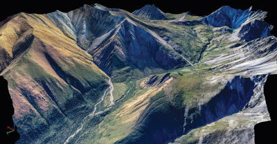
Using drones (foreground) explorers mapped the Tombstone Mountain Range (background) as a demo for the Yukon Parks Branch.
GroundTruth Exploration is a group of relatively young people who are actively seeking solutions for mineral exploration. They have developed several technical advancements and new survey methods. In 2012 they introduced high resolution DC resistivity/induced-polarization (IP) surveys (5-m electrode spacing) as a viable method to detect near surface mineralized structures under soil anomalies. The following year they started using unmanned aerial vehicles (UAVs) or drones to survey the Yukon Territory. They also built the first rendition of the GT Probe as a more cost efficient and environmentally conducive replacement to traditional heli-portable excavator trenching. Last year, they developed the GT Rotary Air Blast (RAB) drill brought online as efficient method to drill exploration targets to 100 m depth at 20% of the cost of traditional diamond drilling.
Showing a black-and-white photo of a gold panner from the Klondike gold rush, he explained that these recent exploration achievements were an accumulation of research and development over the last two years while looking for gold in the same region.
“Using modern technology we are trying to crack the same nut as this guy 115 years later,” Ryan said. “We had a lot of success with the White and the Coffee deposits. However, when the downturn hit, we knew we had to come up with a better solution.”
In his presentation, he described an exploration program where drones are used to map the worksite and generate a 3-D blueprint. The team then uses DC/IP surveys to look for mineralized structure. Instead of trenching, they use probes to take rock and soil samples from a depth of 6 to 9 ft. Once they have identified an anomaly, they fly the GT RAB drill to the site using a helicopter to collect samples. He likens the group to a precision military reconnaissance team that enters a targeted area, gathers a valuable amount of intelligence and leaves with hardly a trace. The days of prospecting by trenching long distances through the bush and large scale diamond drilling programs may be numbered.
 Drone imagery in cloud point format (left) can be enhanced with digital elevation models (DEM).
Drones Supplant the Rod Man
Drones have gained a lot of popularity in the last two to three years in the mining business and great leaps have been made as far as processing the resulting imagery. Some of the new drones, Ryan explained, can cover 1.5 km2 in a 30- to 40-minute flight and for a fraction of the cost of traditional air photogrammetry.
“We wanted to develop a 3-D blueprint of our worksite, which sounds quite logical, but it was costly to do it by traditional means,” Ryan said. “These little guys can be hand-launched from the helicopter pad, they do remarkable work and then they return to the helicopter pad.”
Showing a high-resolution Orthomosaic image, Ryan explained how the imagery delivered by the drones has 3- to 4-cm ground resolution. “This is air photogrammetry on steroids,” Ryan said. “These images have 30 to 40 triangulation points. It’s very high accuracy stuff.” Ryan shows a pixelated image and then explains to the audience they are looking at trees in the Yukon from ground level.
The drones and the controls are carried in small cases. “We can watch them from anywhere, but we like to run them from hilltops,” Ryan said. “A preset program determines the pattern the drone flies. Occasionally we put them down in the bush and they survive.”
The imagery can be used for structural interpretation, mapping outcrops, ground cover and for baseline pre-work ground disturbance for environmental and land use purposes. When combined with digital elevation models (DEM), Ryan explained, the technology can produce 3-D views of a project that can be used for presentations such as this or for investors or a board of directors.
Showing a tin mesh 3-D model, where the computer has stripped away the vegetation, he points out geological features. “Look at this resolution,” Ryan said. “This is what gets us going. There is a thrust fault; mineral exploration is getting fun again. We can provide high quality data from the middle of nowhere.” And, the drones can fly any time of the year.
 Data from the drones is used to create a 3-D blueprint.
Low Impact Drilling
Traditional exploration programs involve large soil-sampling programs. In 2001, as an example, Ryan said they processed 200 samples. “Once we found a system for gathering data, as far as quality and speed, we started ramping up at an accelerated pace,” Ryan said. In 2006 they processed 12,000 samples, followed by 75,000 in 2010 and 170,000 in 2011. They were producing lots of data quickly and they needed to develop a method for processing it.
Using a CanDig Mini Excavator, the teams would dig a 1- to 1.5-m trench to collect samples. “We could sling it in and it worked all day on 2.5 gallons of gas, and it was better than six guys with shovels,” Ryan said. “This worked for finding the White and Coffee deposits. When the downturn hit in 2012, we knew we needed to find a better way to explore the Klondike.”
Low impact, DC resistivity surveys offer a cost-effective way of looking under the ground. The lightweight system uses 56 to 84 electrodes and runs on two 12-volt batteries. “It’s low impact,” Ryan said. “Four guys and a helicopter can conduct the survey without cutting lines or clearing brush. We’re no longer dragging cables through the bush.”
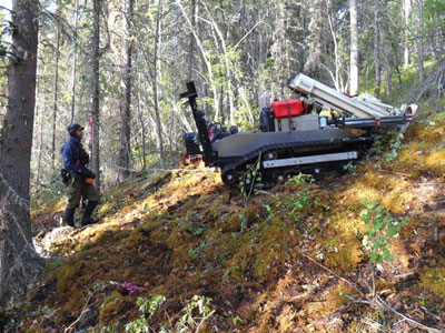 Tao Henderson, vice president, GroundTruth Exploration, tests the GT Probe on a steep slope.
Ryan and his team have been experimenting with the spacing of electrodes and they incorporated a rock property mini-lab for measuring outcrops and specimens. “A lot of people talk about this, but not too many are actually doing it,” Ryan said.
“Traditionally, when we identified a soil anomaly, we would trench an area for kilometers,” Ryan said. “Now just we run the DC resistivity surveys over it and find the targets.
“Once you identify the structure, you have to kiss it,” Ryan said. For that, they have developed the GT Probe, a remote control, light weight (2,200 lb), helicopter portable, hammer drill that runs on hydrostatic-drive with rubber tracks. It gathers soils, till or rocks at the bedrock interface with a 3-in. sampling tube. The unit is less than 5 ft wide and can work on extreme slopes up to 45°. “When compared to a traditional mini-excavator trenching program, the GT-Probe covered—at 5 m sample spacing—three to four times the daily linear distance and came in at 20% of the overall cost, all the while having very little environmental impact,” Ryan said.
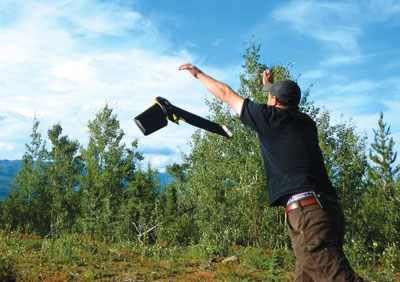 Isaac Fage, president, GroundTruth Exploration launches a drone.
“During the first year, we were only drilling 12 holes per day, Ryan said. “The second year, we improved to 24 holes per day and remodified it to now drill 44 holes per day with no reclamation worries. We are in and out of the area in one pass.”
The GT Probe samples to depth of 6 ft. “The first year we went to bedrock interface,” Ryan said. “However, for consistency, we have now opted for 6 ft. We are also taking an XRF analysis of the bottom of each hole.”
With a signature for each hole, the team creates a daily histogram, showing everything they are doing live—even the geophysics. They convert that data and provide it to the customer that day. In the evening they can overlay the data on the Ortho photo (drone imagery). “We still send the bottom of the hole for assay, but we can improve the grid by the next morning with extra lines of data,” Ryan said. “We are trying to gather quality data live.”
 The heli-portable GT Probe is compact.
The GT Probe trams through the bush with little or no impact. “If you are 20 minutes behind it in the bush you can’t follow it,” Ryan said. “The system also works in the winter. Two years ago, if you asked us for data in the winter, we would have said no way, not until June. We are now punching holes like crazy at -35°C.”
Many of these advancements have been developed by GroundTruth since the downturn in 2012. “We didn’t have these tools two years ago,” Ryan said. “We have now tripled production and removed reclamation costs.”
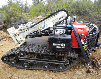
After they’ve located the anomaly, they have to drill it. For this, GroundTruth developed the GT RAB drill along the same lines as the GT Probe. Mounted on the same rubber tracked chassis, it is a small, lightweight (3,000 lb) RAB drill outfitted with an onboard compressor. The unit is helicopter portable.
Ryan explained that, after they debuted the first RAB last year at PDAC 2014, they decided to scrap that unit and rebuild another from scratch. “We now have a mobile drill platform that can be run in winter or summer and drill a 3.5 inch open hole down to 40- to 50-m depths in a single day,” Ryan said. “If the RAB is connected to a larger stationary compressor with 500 m of lay-flat hose, it has the capacity to drill to depths of 100 m in a 12 hour shift. When compared to traditional helicopter diamond drilling, the RAB drill came in at 20% of the overall cost.”
Some were worried about the smear effect on samples from an open RAB hole, Ryan explained. “We punched through 20 g gold intersections over five feet,” Ryan said. “If there was no gold in the next five feet, we wouldn’t know until we diamond drilled it. There was 0.5 g for 5 ft then 0.3 g over the next 5 feet, then nothing. We went through 2 g intersections over 5 ft the next 5 ft section was 0.3 g, so the tail was five to 10 ft. For a unit that drills for 20 cents on the dollar, you don’t have to worry about it.”
 The GT RAB can drill 3-in. holes to a depth of 100 m without a platform.
Providing Quality Information
The team is gathering a lot of data, but they needed to make it more useful for the people raising money to support them while they are working in the bush. “The people in Toronto and Vancouver pouring millions of dollars into these exploration programs are gamblers at heart,” Ryan said. “They get burned with low success ratios. If we can show them samples and the geophysics, and correlate them with high-resolution views of the structure, they will have a better understanding of this deposit. We have improved the probability for them on this gamble.”
This new methodology—quality science and cost-effective, non-invasive exploration program—will bring this market back, Ryan explained. “We are now running the Yukon exploration program 12 months out of the year, which we couldn’t do before,” Ryan said.
The drone imagery serves another purpose. “We will fly the property to create the 3-D blueprint and then we re-fly it when we leave the property,” Ryan said. “We give both renditions to the First Nations and mine inspectors. They usually look at it and ask: Where were you guys working? Trust builds as we demonstrate that we can operate in an environmentally sensitive manner.”
The probability of finding an anomaly with these new technologies has improved substantially, Ryan explained. “We can now pursue a high-quality target with a handful of permits,” Ryan said. “In the past, we were applying for all of these permits and drilling thousands of holes when there was nothing really there.”
Ryan and GroundTruth have combined several steps, which were advancements enabled by technology, and applied it as a package. The Yukon prospectors are turning a gamble into a case of probability.


