


High resolution map showing thorium concentration in parts per million. Mira Geoscience used automated clustering algorithms to establish the different lithological groups according to the radiometric and magnetic signatures. (Photo: Mira Geoscience)
Machine learning, hydrogeochemistry, SQUIDS, and other techniques are increasing the speed and success of tomorrow’s undercover exploration programs
By Carly Leonida, European Editor
The next five to 10 years signal a turning point for the mining industry. Demand for metals such as copper, lithium and cobalt is set to skyrocket as the green economy expands and demand for low-carbon technologies like electric vehicles and wind turbines increases.
Gold, a safe haven for investors during times of uncertainty, also looks set to remain in high demand as we enter a period of unprecedented global change fueled by climate-related risks and trade tensions.
Demand may be in our favor, but across the industry, average grades are falling and this puts greater pressure on operational mines to extract and process more material, potentially shortening their economic lives if new deposits or extensions to existing ones are not unearthed. In addition, the rate of success in the discovery of greenfield deposits and the speed at which we can develop those we do find, is no longer keeping pace with that of extraction and this, quite rightly, is a significant source of worry for mining companies and economists alike.
To reach our low-carbon energy targets and remain on a (relatively) even keel both politically and economically, the world needs more metals. But, how to find them? Most easy-to-reach, near-surface deposits have been exhausted. The future of mineral exploration lies undercover and for those who know how to find them, treasures still await even in some of the most mature jurisdictions.
The Digital Revolution
While exploration once saw geologists and drill teams in the field with naught but a few outcrops, hand samples and some historical maps to go by. Programs today look very different. We live in a digital age and new data management, modelling and predictive tools are constantly being added to the geoscientist’s arsenal.
Always a good indicator of trends in exploration, the AME Roundup exhibition that was held in Vancouver at the end of January, featured a number of technical sessions dedicated to emerging exploration techniques.
One such topic, and one that has received much attention across the industry and its disciplines of late, is machine learning, a subset of artificial intelligence. Jean-Philippe Paiement, director of global consulting at Mira Geoscience, was one of a team of experts who led a short course dedicated to machine learning at the event.
E&MJ caught up with him and John McGaughey, Mira Geoscience’s president, afterward to find out more.
“Machine learning or artificial intelligence (AI) is often seen as a black box — hard to interpret and trust because the workflow, decision factors and algorithms can seem obscure,” Paiement said. “However, its meaning can be simplified to the application of computational mathematics to big data problems. A model is constructed to automate prediction or decision-making, whether it is a regression problem (predicting values from data) or classification problem (classifying data based on a multitude of variables).
“Not only will the algorithm make a prediction, but it may open the door to new ideas by pointing to previously unrecognized correlations and ranking the importance of individual data sets.
“Thinking outside the box is necessary to make new discoveries as exploration is becoming harder, with greater focus at depth or undercover,” Paiement added. “AI applications to interpretative problems can remove cognitive biases from interpretation and provide in-depth insights into multivariate environments.”
McGaughey put this into context: “Traditional approaches to data integration applied to geology typically focused on statistical classification models, employing numerous assumptions that are generally not met in practice,” he said.
“Recent, successful advances have been made in stochastic, non-Euclidean approaches to the problem of understanding complex data relationships. Predictive models are constructed from the integration of complex data sets without the limiting assumptions of traditional statistical approaches. These new approaches can easily handle continuous, discrete, noisy and missing data with limited impact from interpretative assumptions.
“Over the last five years, machine learning has been a growing subject of conversation in the mining industry, but there has been lots of confusion as to how to apply it correctly and generate useful outcomes for the mining industry. Its practical application in the context of image filtering and recognition, geochemical interpretation, remote sensing and predictive exploration models are already having impact on standard practices in numerous companies.”
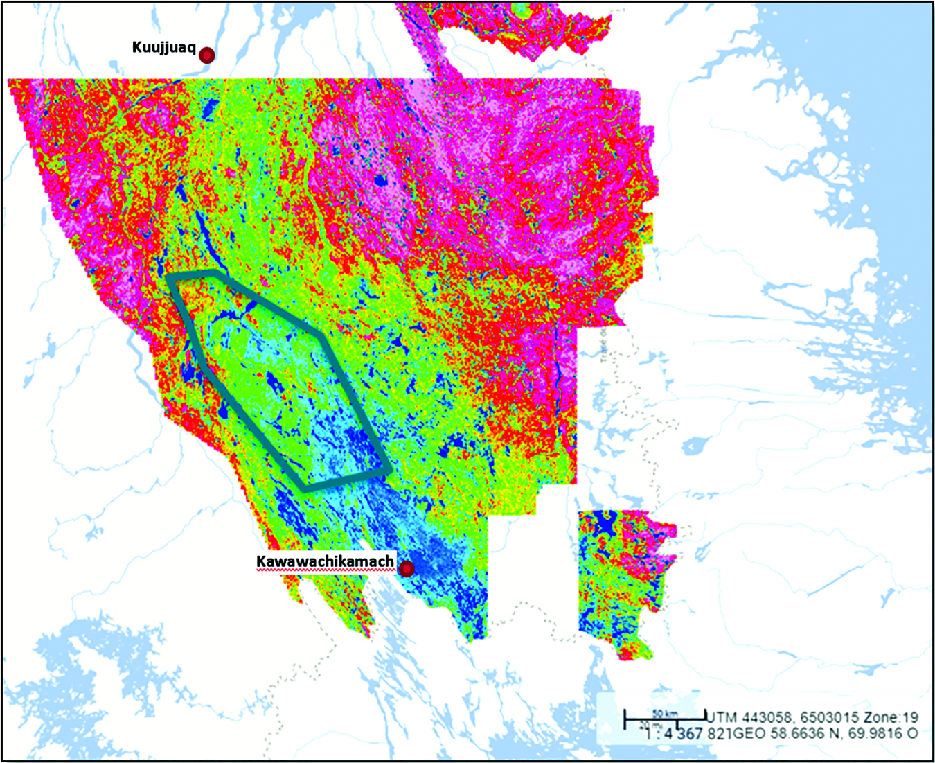
This map shows clusters that represent probable geological domains within the Labrador Trough located at the Québec-Labrador border. (Photo: Mira Geoscience)
Re-learning Exploration
The potential benefits of AI in mineral exploration are huge, yet its application is far from simple. In the example of mineral deposit targeting, explorers are trying to identify the location of ore deposits at the core of a very complex, natural system, created over millions of years of geological processes including structural reworking and hydrothermal alteration.
Evidence of the deposit footprint must be assembled from interpretation of subtle alteration effects extending kilometers from the target. This is a very different and more complex circumstance than can be found in traditional applications of AI.
The route to solving these challenges includes taking the focus off the methods of AI as a discipline and putting the focus on how the mineral exploration problem is set up for AI predictive models to work coherently. This is where deep domain knowledge and a mining industry-specific, supporting computational framework is required.
It is also important to note that the application of machine learning techniques within earth sciences is still in its infancy and, as a result, no algorithms have been developed specifically for this field yet.
Paiement explained: “Depending on the problem one is trying to solve, different algorithms can be used — there is no single best algorithm out there. It would be difficult and wrong to steer users into a single type of algorithm. A deep knowledge base of machine learning and domain-specific geoscience knowledge is key to choosing the appropriate approach to solving each individual problem.
“From different tests, it seems that in the case of making prospectivity score predictions in geological environments, the Random Forest approach works well. However, when interpreting geochemical pathways and alteration halos, it might be best to use hierarchical clustering approaches. The key does not lie in the application of the algorithm but in the data preparation, labeling, and training versus test set preparation. A lot of issues may arise from incorrect data preparation that even the best algorithm cannot solve.”
Every data scientist I’ve spoken to over the past decade has stressed how important data quality is to the outcomes of a project. If the data quality is good, most mathematical problems can be solved by high performance computers that users can buy off-the-shelf or by renting computing time on cloud platforms in a relatively short space of time. The answer lies in correct data preparation and merging, which represents up to 80% of the work, prior to running the algorithms.
“Quality is not always the focus of data collection campaigns,” Paiement said. “We are often faced with generations of legacy data where quality is a particular problem. Setting up the problem correctly and identifying the relevant data to apply machine learning techniques are the key steps in the workflow.
“In the future, companies should focus on data acquisition with the thought that it will provide value for years to come, not just the current exploration campaign. This is true for all types of sampling sources (i.e., drilling or fieldwork) and should include systematic high-resolution pictures (including hyperspectral), physical rock property measurements (magnetic susceptibility, density, conductivity), and geochemical assaying for every sample. It would be very useful for systematic wireline logging to gain more traction in the minerals business.”
McGaughey added: “At Mira Geoscience, we have developed a supporting data management and computational framework through intensive, industry-collaborative R&D over the past five years, directly addressing the problem of quantitatively integrating 3D and 4D mineral exploration data sets and interpretation.
“The system is called Geoscience INTEGRATOR. It brings together structured and unstructured data and interpretation, from drill hole data to all types of geological, geophysical and geochemical data. It is fully 4D, tracking both space and time. Documents and files can be stored, managed, and linked to data and interpretation to provide relevant metadata and contextual links. It is the industry’s first multidisciplinary, 4D data management framework and, as such, delivers the platform required by computational systems such as AI, that aim to answer questions that only quantitative data integration can answer.”
Most importantly, Mira’s system provides a “data fusion” capability specifically aimed at mining industry problems.
“This is game-changing technology for mineral exploration,” McGaughey said proudly. “It provides a sound, robust solution to the once-intractable problem of integrating highly disparate data across space and time.”
Putting Machine Learning Into Practice
The beauty of machine learning is that it is applicable across every commodity and exploration program. Paiement said that more and more mining companies are turning to advanced modelling in the bid to make more informed decisions in their projects.
“These types of approaches have the benefit of being probabilistic and make it easier to quantify the risk associated with the different modelling steps,” he explained. “For example, the use of probabilistic geological models would be beneficial to all geologists by building models based on lithological probability and remove some cognitive bias out of the interpretation work.
“There is still a significant amount of work in order to make these new modelling and statistical methods more accepted by the mining industry, but they offer so much more power in terms of decision making, risk assessment, drilling optimization and general exploration successes.”
Paiement gave the example of a recent project where Mira Geoscience used radiometric data to generate automated alteration maps based on residual values.
The radiometric spectrometry method is a geophysical tool used to estimate concentrations of potassium, uranium, and thorium by measuring gamma rays emitted by radioactive isotopes of these elements during radioactive decay.
Some alteration profiles, such as potassic alteration, which is often associated with hydrothermal deposits, can be detected using gamma ray spectrometry.
In outcropping or low-coverage environments, it is thus possible to map the different lithologies and potentially estimate changes in potassium and uranium concentrations caused by alteration processes.
“For this project, we used automated clustering algorithms to establish the different lithological groups according to the radiometric and magnetic signatures, coupled with geological calibration,” Paiement explained. “Once the dictionary of lithology is created for the study area, it is possible to estimate changes in mass for potassium and uranium, which are characteristic of the various alteration processes.
“The immobile nature of thorium allows us to estimate thorium-potassium and thorium-uranium regression and also actually calculate the residual values for the more mobile elements, potassium and uranium, which can be affected by hydrothermal fluid circulation. This mapping method makes it possible to highlight zones of leaching and deposition of these radiometric elements.”
This approach allows rapid generation of more accurate alteration maps than the ternary maps traditionally used for exploration of mineral systems associated with iron oxide copper-gold (IOCG), uranium, porphyry, and other systems that have a large footprint and affect potassium and uranium compositions.
“In order to test the workflow proposed above, we chose the Labrador Trough at the Québec-Labrador border because of its low level of Quaternary cover and potential for IOCG mineral deposits,” Paiement said. “These types of deposits come with a substantial alteration footprint that might be mappable using the automated approach proposed here. The data was downloaded from the Quebec public repository and re-gridded at a 500- x 500-m resolution for fast processing.”
First, lake and swamp-environment signatures were taken out of the survey using a first round of clustering and domaining. This allowed the Mira team to concentrate on the signatures associated with the rock units. Following this first step, the magnetics data was also processed using a high-pass filter to focus on the short-wavelength signature associated with near-surface changes in the magnetics.
The data set consisting of the potassium, thorium, uranium and magnetics was then run through a hierarchical clustering algorithm.
“This algorithm enabled us to group the datapoints (grid cells) into domains of similar signatures in the four input dimensions. The advantage of using this type of algorithm lies in its interpretability and customizability in terms of resulting clusters. Given the model’s performance and entropy, it was established that eight clusters existed in the data set, representing probable geological domains.
“Using those eight domains, 3D regressions were estimated for potassium from uranium and thorium, for uranium from potassium and thorium and for thorium from potassium and uranium. A regression for each domain was estimated and the residual values for each element were then calculated.
“Lastly, the three residual maps are combined to generate an alteration map for potassium and uranium mass balances potentially associated with IOCG alteration. When comparing the alteration map to the known deposits, certain trends become visible,” Paiement said.
For those who are keen to learn more, the Concepts and Application of Machine Learning to Mining Geosciences short course will be offered at PDAC 2020 in Toronto in March.
“Following this, other more specific course might be proposed,” Paiement added. “We also offer customized training for companies looking to focus on key areas of their work.”
Explorers Harness Hydrogeochemistry
In case this article has not proven technical enough thus far, lets add some geochemistry into the mix. Hydrogeochemistry to be specific.
The use of hydrogeochemistry in mineral exploration programs is increasing worldwide and particularly in Australia, although many experts still consider it underutilized. The technique offers a relatively low-cost and unobtrusive way to hone potential mineral targets over large areas, which is especially valuable given that the vast majority of undiscovered deposits do not outcrop at the surface.
In the 2011 Field Guide for Mineral Exploration using Hydrogeochemical Analysis guide published by CSIRO, Gray et al. explained that the method exploits the interaction of groundwater and different geological systems to distinguish where mineralization is likely to occur. Groundwater is sampled in areas of interest and concentrations of pathfinder minerals studied to indicate probable areas of mineralization. The inferences gathered via this technique allow the more accurate application of traditional exploration methods such as drilling or trenching to confirm the location and economic viability of deposits.
One organization that is using hydrogeochemical exploration with great success is Nevada Exploration. The company is advancing a portfolio of new district-scale projects along Nevada’s Cortez Trend and has been using hydrogeochemistry since the early 2000s to search for new Carlin-type gold deposits.
Nevada is the world’s biggest gold producer by area, but more than half of the region’s bedrock lies covered beneath its valley basins, which have seen minimal exploration to date because conventional exploration methods offer limited success in covered terranes.
“In addition to being covered with valley basin fill (sand, gravel, etc.), Nevada’s vast covered valley basins are also saturated with groundwater,” explained Nevada Exploration President James Buskard. “Water is known as the ‘universal solvent’. As groundwater flows through the subsurface and interacts with the covered bedrock below, the groundwater acquires a unique hydrogeochemistry signature or ‘scent’ representative of the bedrock it has encountered, providing valuable geochemical information in covered settings, and representing an important and underutilized sampling medium.”
Buskard said when groundwater interacts with a gold deposit where the gold is contained within soluble mineral complexes, such as pyrite and arsenopyrite in Carlin-type gold deposits (CTGDs), these soluble complexes oxidize and release gold (plus related trace elements) into the groundwater, producing a measurable and recognizable hydrogeochemistry footprint.
Because groundwater mixes and flows, a deposit’s hydrogeochemistry footprint is often much larger than that seen in other sampling media. This can significantly reduce the sampling density needed to detect a target, and thus decrease the number of samples needed to evaluate large search spaces. Beyond increasing the size of a deposit’s geochemical footprint, groundwater movement can also define a gradient or vector pointing back to its source, and because groundwater can recharge from depth, sampling groundwater can provide opportunities to detect deeper mineralization.
Groundwater and Gold
Unlike blind drilling and geophysics, groundwater sampling provides direct and low-cost geochemical information.
“By providing opportunities to increase the size of deposit footprints, reduce the number of samples needed to evaluate an area, vector toward mineralization, and detect deeper mineralization, hydrogeochemistry represents an ideal geochemical exploration tool for opening up covered search spaces to systematic exploration,” Buskard added.
“In terms of gold exploration, the best hydrogeochemical pathfinder for gold is gold itself. Despite its relatively low solubility, with proprietary sampling protocols and the latest ultra-trace laboratory analytical methods, Nevada Exploration has established workflows to achieve the robust part-per-trillion (PPT) level analysis needed to detect and respond to gold in groundwater directly.”
Even with PPT-level analysis, due to physical and chemical groundwater processes such as mixing and adsorption, a practical implication of gold’s low solubility is that the size of a deposit’s detectable gold-in-groundwater footprint is generally smaller relative to that of other hydrogeochemistry pathfinders. Based on the results of large groundwater characterization studies around known gold deposits in Australia and Nevada, researchers have shown that the ideal sampling density to respond directly to gold in groundwater during regional-scale exploration is in the order of one sample per square kilometer.
Buskard said most groundwater sampling programs rely on collecting groundwater samples from existing boreholes, so explorers often have no control over sampling locations. Without the ability to collect samples at a density suitable to respond to gold in groundwater directly, explorers have had to rely on more mobile, but less diagnostic, pathfinders such as arsenic and antimony.
“Furthermore, with no control over sampling locations, explorers have been unable to integrate hydrogeochemistry with other geologic tools to provide this important geochemistry data across search spaces identified as prospective based on other lines of evidence, such as projections of favorable geology or geophysics,” he added.
To combat this, Nevada Exploration has developed specialized equipment to create purpose-drilled boreholes. This equipment has significantly reduced its costs, and Nevada Exploration stated that it can now evaluate covered terranes in Nevada for approximately $1,000/km2, which it describes as a “radical cost breakthrough.”
SQUIDS Delve for Diamonds
De Beers Exploration’s current focus is on priority greenfield areas in Canada, Botswana and South Africa where the company is looking to discover economically viable kimberlites and secondary diamond deposits that could add significant new production.
“Our brownfield work is mainly focused on areas adjacent to our existing mines and around the Chidliak project in Canada,” Anre Vorster, senior manager, future exploration and projects, told E&MJ.
“Exploring for diamonds is not only technically challenging, consideration is also required of the various legal-commercial elements — many of which are unique to the particular country we’re operating in — as well the need to carefully manage multiple and often differing stakeholder interests. In addition, undiscovered diamond sources are likely to be in areas of complex geological terrains and/or under thick overburden, which add to ever-increasing costs of exploration. These aspects all need to be carefully managed whilst ensuring safe discovery in remote and challenging locations.”
The Full Tensor Magnetic SQUID (Superconducting Quantum Interference Device) project is a collaborative partnership between the Institute of Photonic Technology (IPHT), Supracon, De Beers, Spectrem Air and Anglo American. It has delivered a pioneering airborne geophysical instrument that provides full tensor magnetic data of superior quality that comes with a wealth of information that was not previously available to mineral explorationists.
SQUIDs are very sensitive magnetometers that can detect changes in magnetic fields billions of times weaker than a typical fridge magnet. At the heart of a SQUID is a device called a Josephson junction: two superconductors made of niobium, separated by a thin insulator through which electrons can pass. An electric current is applied to a SQUID, and minute variations in magnetic fields are detected as changes to the system’s electrical resistance. As niobium only acts as a superconductor at temperatures close to -273°C, it is necessary to cool the SQUID by housing it in a cryostat: a container that uses a refrigerant such as liquid helium to maintain it at an ultra-low temperature.
The complete system consists of six magnetic gradiometers and four magneto-meters housed in a helium-filled cryostat along with a digital acquisitioning system comprising of a differential GPS, inertial measurement system (IMU) and altimeters.
De Beers’ Innovation Focus
Although the airborne SQUID magnetic system does provide De Beers with an industry-unique differentiating capability in the search for new diamond deposits, it remains one of many tools in the company’s exploration toolkit.
Other geophysical techniques such as electromagnetic (EM) surveys are also routinely used, and the results are integrated with the SQUID full tensor data to facilitate comprehensive geophysical interpretations of the geology in the search areas.
“New areas may also be covered by sampling programs aimed at recovering heavy minerals to test for the presence of kimberlites, using the resultant mineral chemistry data to determine whether these pipes may have sampled potentially diamond-bearing lithologies/material during their upward journey through the earth’s mantle to surface,” explained Vorster.
“Innovation is a key focus area in De Beers Exploration and we have been developing some exciting techniques and technologies to assist us in not only reducing the time from discovery to delivery of new diamond sources, but also in opening up new areas for diamond discovery and allowing us to detect potential sources that were previously hidden.
“These techniques and technologies span the exploration pipeline and include novel approaches to exploration targeting, developing new airborne geophysical technologies such as the SpectremPlus airborne EM system, in addition to the SQUID, advancing drilling techniques and also developing new laboratory technologies and techniques that could significantly impact the way we treat samples and interpret results.”
De Beers is also harnessing AI techniques to help handle and sort through its mineral exploration data.
“We view AI and machine learning as a key enabler to unlock value from our vast exploration datasets, which span more than 70 years of historic exploration across the globe,” Vorster said. “The main goal is to gain new insights and identify patterns and critical relationships in the geoscientific data that could provide early indications of the economic potential of kimberlites and allow us to prioritize those for further work.
“Our team is collaborating with leading research institutes in several pilot studies and the initial results thereof are greatly encouraging, especially in the targeting space where machine learning is used extensively to focus on globally prospective areas much quicker than before and with increased confidence.”
One thing is for sure: diamond exploration in the distant future will look fundamentally different from today.
“From a technology perspective, high tech data acquisitioning could be largely driven by unmanned aerial vehicles (drones) delivering real-time streamed geophysical data,” Vorster said. “Central data centers and laboratories will use advanced data analytics to process and interpret the data and prioritize high priority anomalies for further follow-up. The use of intelligent equipment, real-time sensors and automated processes will be ubiquitous, such that the footprints and personnel on the ground will be very limited, allowing geoscientists to focus on interpreting the resultant data in new ways.”

The Major Drilling and Osisko teams mark the completion of Canada’s longest diamond drilled hole.
Osisko Completes Discovery 1 Deep Drill Hole
Osisko Mining said it has drilled the longest diamond drill hole in Canada at its Discovery 1 project. The final length of Discovery 1 was 3,467 meters (m).
“Discovery 1 is a great success and achievement,” said Osisko President and CEO John Burzynski. “We are very proud of our Osisko team and Major Drilling for their tremendous work completing this hole.”
Discovery 1 was a planned 3,000- to 3,500-m-deep drill hole, designed to target two down-plunge extensions of known gold zones and investigate the projected source area of the Windfall deposit at depth. The working model for the Windfall deposit interprets an outer shell and center of a possible porphyry intrusion feeding the Windfall-Lynx gold system.
“It is an honor to have been a part of this monumental project,” Major Drilling President and CEO Denis Larocque said. “We are proud of the hard work and expertise that our team has contributed along with Osisko Mining to reach this historic milestone in Canadian drilling.” Over the years, Major Drilling has positioned itself as one of the largest specialized drilling operators in the world, by leveraging its skilled personnel, specialized equipment and robust safety systems.
Burzynski pointed to other successes working with Major Drilling that include the discovery of the Underdog and Triple 8 extensions, the wide intercepts of anomalous gold values similar to those observed in the Lynx system, and now these new high value gold intercepts at depth. “These results of the Discovery 1 hole show that the Windfall system is extensive with substantial room for potential growth,” Burzynski said.
In addition to holding the record as the longest diamond drill hole in Canada, it also achieved a vertical depth of 2,700 m from surface. Analytical results from the final 200 m are at the laboratory, results are pending. The hole was drilled from surface to 3,149 m with NQ rods and finished with BQ rods.

Unearthed’s Holly Bridgwater exploring data driven exploration technologies. (Photo: Roy Vandervegt)
South Australian Government Challenges Data Scientists to Find Next Olympic Dam
This year, the Marshall Liberal Government will become the first government globally to host a $250,000 crowdsourced open data competition to fast-track the discovery of mineral deposits in South Australia.
Hosted with open-innovation platform Unearthed, ExploreSA, the Gawler Challenge will see geologists and data scientists from across the globe try their hand at uncovering new exploration targets in the state’s Gawler Craton region using mathematical expertise, machine learning and artificial intelligence.
The South Australian government is the custodian of an extensive amount of geological data across the state, be that data the government has collected to support exploration activities or data they host that has been recorded by private companies. However, historically, it has been a challenge for people to process this data at scale.
Crowdsourcing enables the government to readily share this considerable collection of datasets with people from different disciplines around the globe who can apply their diverse experience and skills to mineral targeting. It also empowers these data scientists, geoscientists and mathematicians to collaborate and work through the data in novel ways. This encourages the development of new workflows, through the application of emerging machine learning and analytical processes to exploration geology.
“This state-of-the-art competition has the potential to unearth the next Olympic Dam or Carrapateena by encouraging global thinkers and innovators to interrogate our open-file data and generate new exploration models and ideas for targeting,” said Minister van Holst Pellekaan.
“Mining is one of the pillars of the South Australian economy and this competition should add to the pipeline of projects in the resources and minerals processing sector.
“Our existing inventory of discoveries suggest there are major prospects and many other deposit styles and commodities to be identified and this will only serve to bring those internationally significant discoveries forward.”
All targets generated, including those from the winners of the A$250,000 prize pool, will be publicly shared to increase innovation and understanding in the resources sector by enabling access to data science approaches and modern geoscience thinking.
Unearthed Industry Lead, Crowdsourcing, Holly Bridgwater said the competition served to leverage data science to its full potential at a time when significant new discoveries are becoming rarer.
“This exciting crowdsourcing competition and world-class open dataset will attract a global community of innovators, some of whom won’t have worked in the mining industry before,” Bridgwater said.
“We can’t wait to see how they will apply their diverse skills, fresh ideas and novel approaches to mineral exploration to accelerate discovery in South Australia.”


