


 |
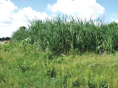
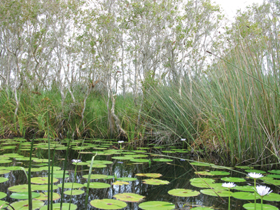
| In many cases, the assessment of environmentally challenging areas such as wetlands is not done with enough care and depth—or by qualified experts. |
Several countries, including the U.S., Australia and Brazil, place regulatory requirements on how mining operations must manage and protect wetlands. Although each country has its own requirements, the challenges mine operators face in gaining permits and executing permitting successfully are the same—namely, poor resource allocation (not timely assessing the natural resources on a project site), financial stress (delays from the permitting process), and negative external publicity.
One way to overcome the challenges of the permitting process is to implement a comprehensive wetlands compliance solution. Comprehensive compliance is an approach that relies heavily on technology and early teaming with local, regional, and governmental stakeholders, geographic information system (GIS) and database technologies, and risk management methodologies to assess the natural resources, including wetlands, on a proposed project.
Regardless of the unique regulatory requirements that might apply to a mine, there are three primary components of a comprehensive wetlands compliance solution. They are due diligence, stepped coordination and a sound monitoring/awareness program.
CONTINUOUS DILIGENCE
It seems self-evident that the evaluation of any property that might include potentially challenging or problematic environmental conditions such as wetlands should be evaluated in advance of the purchase or lease of property.
Data that supports these land assessments often includes infrared and true color imagery, topographic, soil and floodplain maps, as well as hydrologic (ground and surface water) data. GIS is the ideal environment to pull these maps together into a single database and evaluate project environmental conditions.
But what happens next?
In many cases, the assessment of potentially environmentally challenging conditions such as wetlands is not done with enough care and depth by qualified experts. Oftentimes, the early environmental assessments are left to the environmental health and safety manager or mine engineer. In most cases, this individual is not allocated adequate time to conduct the evaluation because of other responsibilities or doesn’t have the necessary expertise to make a true evaluation.
Rapid or less-than-thorough assessments can be costly.
Beyond the gathering of data and assessment, the site assessment must include project boundary data along with the mine reserve limits. The individual should always start with a desktop evaluation followed by a preliminary field review to verify approximate limits and quality of wetlands, and then review the mine plan to confirm wetlands that will need to be impacted. Following the desktop evaluation and preliminary field review, the mine operator should have the wetlands that are within or of close proximity to the limits of mining delineated and evaluated for agency jurisdiction. It is then that the mine operator can make decisions as to which wetlands can be avoided and which may require permits to disturb.
Depending on the size of the project, a desktop and preliminary field review can be conducted fairly quickly. An environmental assessment of 2,000–4,000 acres won’t take more than a couple of weeks at very little cost compared with the owner’s overall investment in the property; and it is money well spent when considering the time and capital wasted if a property that cannot be mined is purchased. Due diligence prior to land purchase and permit submission should be step one.
 |
| A comprehensive wetlands compliance solution relies heavily on technology and early teaming with local, regional,and governmental stakeholders, GIS and database technologies, and risk management methodologies. |
STEPPED COORDINATION
The coordination of pre-application meetings with appropriate federal, state and local environmental agencies is common and, in many cases, required. However, so often property owners don’t use this opportunity to fast-track the permitting process nearly enough.
The first pre-application meeting is the first opportunity for agency representatives to see the area in question, discuss the mine operation plan, provide the site plan depicting the approximate limits of wetlands and impacts, discuss avoidance and minimization of impacts, and schedule field meetings.
Follow-up meetings let an environmental team share the wetland field delineation and mapping results and the continually updated mine plan with the environmental agency representatives and respond to questions that the agency might have come up with over time.
A third element of the pre-application process might be to conduct a site inspection with the permitting agency to verify delineation mapping. Weekly conference calls with the agencies further build the relationships and assure the owner that there won’t be any surprises once the permit application is submitted.
Throughout the process, the owner is developing a relationship with the agency while gaining a clear understanding of the permitting requirements.
What’s the benefit of this extra work? In short, less time to permit approval and potentially the early understanding that a property may not be feasible to purchase.
In one recent example, Kleinfelder used the stepped permit coordination plan to support the permit process on a large mine in the southeastern U.S. The team was able to obtain the necessary permits in just six months—a permit that the owner and many others expected would take several years
MONITORING/MAINTENANCE
Once the permit is obtained, the application of the field delineation solution must be carefully executed to meet the requirements of the permit and the federal, state or local rules that apply.
Here are some key action items:
• Update ArcMap database to incorporate any final changes made during permitting.
• Mark/flag the limits of any areas of the property that are not to be disturbed.
• Conduct training of mine operations personnel so they understand the site limitations and the areas not to disturb.
• Prepare a schedule for any monitoring and management if applicable.
• Put quality controls in place:
o Third-party audits of construction;
o Conduct inspections following site management activities.
• Be diligent.
The challenge in the execution of a plan is ensuring that everyone working at the site understands the limits of the operation. This can be a challenge to smaller startup mining operations or in operations with limited funding or coordination to conduct and complete tasks.
Also remember that permit limits should be flagged, painted or in some way identified in the field. A permit compliance person should be on site. If that’s not possible in a full-time capacity, hire a consultant to fill in the gap. A consultant can perform regular audits and check-ins, either full time or part time. Remember that permitting agencies will perform regular inspections.
Operators using a comprehensive compliance program—that includes due diligence, stepped coordination and a sound monitoring/maintenance—are in a stronger position to address stakeholder concerns and at an advantage when addressing potential issues and challenges. By collaborating early and continuing to work together throughout the permitting process, operators, government representatives, and state and local regulators are able to avoid common missteps, including ineffective communication and scheduling concerns.
Ed Murawski is a project manager with Kleinfelder, specializing in plant identification, land use mapping, federal wetland determination/delineations, protected species management, environmental due diligence evaluations, land use permitting, and wetland restoration/creation design, monitoring and management. He can be reached at (813) 887-3900 or emurawski@kleinfelder.com.


