


RockWare has released RockWorks 16, the latest version of its flagship suite for visualizing surface and subsurface data to help geologists import, display and analyze data more quickly and accurately.
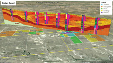 According to the company, the new version makes navigating and expanding a borehole database easier than ever. With the improved organization, new sorting options, and ability to group or hide boreholes, users can isolate holes of interest quickly. The software now can reference downhole data tables to either the ground or collar elevation, and it supports unlimited commentary on lithology, stratigraphy, water level, well construction and other relevant areas. Its 2-D and 3-D viewers also have received major improvements. For example, the tools for handdrawing cross sections snap to lines and polylines to prevent gaps from appearing between correlated stratigraphy. Polygons and polylines on contour maps include vertices so they are easy to edit. In 3-D scenes, users can save viewpoints to quickly retrieve specific views. The new version offers enhancements to the stratigraphy and lithology pickers, such as smart stratigraphy rules for handling missing tops and bases, and other improvements such as expanded tools for moving data to and from Google Earth and support for new map types.


