


 Geovariances says its Minestis software provides a structured workflow that guides the user step-by-step through a resource modeling project.
Geovariances has launched Minestis, a new software solution designed for mineral resource estimation.
Minestis, according to Geovariances—a French independent software developer specializing in geostatistics—offers a fast, easy workflow for domain estimation and mineral resource modeling through a simplified and secure geostatistics-based approach.
When designing Minestis, a main objective was to offer customers a new generation mining-focused software solution that non-experts in geostatistics can learn and implement easily, said Geovariances Software Development Manager François Geffroy. “As a result, Minestis simplifies resource estimation and quickly delivers reliable estimates.”
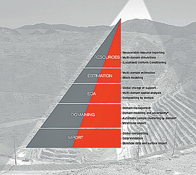
Minestis provides a workflow, which guides the user through every step of a resource modeling project. The software starts with the loading of already built grade shells or geological surfaces and verifies that geological domains are coherent with each other. It continues, with a geostatistics-based estimation process which gives users access to the parameters they need to control through a smart user interface. It terminates with the production of the recoverable resource figures required for subsequent resource classification.
Geovariances said Minestis implements powerful parallelized geostatistical algorithms: kriging, conditional simulations, uniform conditioning and localized uniform conditioning. Additional tools such as automatic variogram fitting or kriging neighborhood analysis, combined with a modern interface, facilitate software use and parameter setting. Early users, said the company, report that Minestis is fast and visual.
Minestis estimates and reports resources in several ways:
- Complete data analysis process with statistics production (histograms, swath-plots, cross-plots), drillhole length regularization, data declustering (statistics help define the best declustering window size), structural analysis on raw and Gaussian transformed grades.
- Facilitated variogram modeling from automatic variogram fitting. Support correction and Information Effect are taken into account.
- Block estimation through ordinary kriging with moving neighborhood. Kriging Neighborhood Analysis helps derive relevant neighborhood parameters.
- Recoverable resource estimation at global and local scales from Uniform Conditioning (UC), Localized Uniform Conditioning (LUC) and Turning Bands conditional simulations.
- Panel and SMU size definition, block kriging, UC/LUC and simulations are run in one hit for each domain.
- Report of tonnage, metal, grade and/or benefit figures for each defined cutoff and for either panel or SMU support, by domain or over the whole study area.
“The strength of Minestis is that it manages the estimation of geological domains and block models in a coherent way, thus ensuring the quality of resulting estimates,” Geovariances Chief Technology Officer Nicolas Jeannée stated. “Another strength is that Minestis also makes recommended advanced resource evaluation techniques like conditional simulations or uniform conditioning easy to implement by non-experts in geostatistics. This means users hold all the assets to get the resource figures expected by their company.”
For advanced optional functionalities, Minestis can be linked with Geovariances’ Isatis geostatistics program.
The company noted that for now, only the companies which sponsored the solution’s related research program can take advantage of Minestis’ innovative implicit domain modeling directly from borehole data. It also enables uncertainty assessment on the domain envelopes, which is unique among mining packages. Domain modeling will be publicly released in 2016.


